WITH GRATITUDE
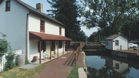
There are a few people who have made a lasting impact on the Delaware Canal, not only in its preservation but also in its promotion as a valuable public space.
We are dedicating this issue of our newsletter to two people, who during their long lives, had an enduring enthusiasm and energy for the Delaware Canal State Park.
Remembering Betty Orlemann
“What you do makes a difference and you have to decide what kind of difference you want to make.”
—Jane Goodall
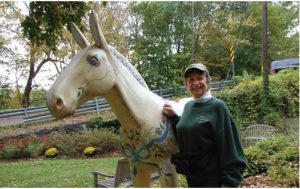 Betty Orlemann, who passed away on April 3,2025, one day after her 97th birthday, founded the Friends of the Delaware Canal in 1982. Even at her advanced age, Betty was still a force of nature.
“Something has to be done.” This short but telling quote from our founder set the tone for the vision and purpose of this organization. In 1977,Betty and her young family moved into an old farmhouse on River Road in Smithtown, adjacent to the Delaware Canal.
Seeing the disrepair and neglect of the canal, bridges, and towpath, Betty Orlemann took action. She organized volunteers to improve the canal and its surroundings, marking the beginning of what
would later become the Friends of the Delaware Canal.
The Friends had their first official meeting in October 1982, and by January 1983, the group was incorporated. One of the first members of this newly formed non-profit was Virginia Forrest.
Betty was also a founder and Board member of the Delaware & Lehigh National Heritage Corridor (D&L) and the creative inspiration behind the Miles of Mules art installation. In 2009, Betty was presented with the first Lifetime Achievement Award from the D&L National Heritage Corridor.
Remembering Will Rivinus
 “No harm is done to history by making it some thing someone would want to read.”
—David McCullough
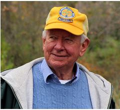
Extensive research and creativity were two hallmarks of Will Rivinus, whose single-minded purpose in documenting a journey along the Delaware Canal will continue to inform and educate
for many generations. Will came to Bucks County and was charmed by the area’s history and natural beauty, as well as the canal and towpath. His first
journey along the towpath took him from Solebury to the Mountainside Inn, where, too exhausted, he
stopped for the evening.
Will would go on to explore the entire 58.9 miles, building his stamina along the way. He started the Canal Walks in 1987, an annual event that helped promote the towpath and the region. His tireless advocacy has been recognized by both the Pennsylvania Senate and the House of Representatives.
Will Rivinus, like Betty, was driven by a deep commitment to improving our Delaware Canal State Park for generations to come. His legacy will continue to have a lasting impact on the park and
its visitors.
Upon the passing of the last of her Canal “elders,” Susan Taylor shares these two stories about them:
Betty Orlemann
Five days into my new job as the Executive Director of the Friends of the Delaware Canal, I was told that a $5,000 match was due on a
grant from the Grundy Foundation. I had two weeks to either find the funds or write a very convincing request for an extension.
Needless to say, I was very jumpy until Betty Orlemann told me, “It will be alright, the Friends have a guardian angel.” I took a bit of comfort in this, but I still needed to do something.
Two days later, the office phone rang. It was a man who immediately started asking about the Canal’s problems and what the Friends did. His final question was “What do the Friends
need?” With the grant match high on my mind, I blurted out “$5,000.” We talked a bit more, and then said goodbye, without me knowing the man’s name.
I didn’t give the conversation a lot more thought. I’d learned early on that many people called to ask about the Canal. And then came an envelope in the mail. Inside was a $5,000 check. After I got over my amazement, my first thought was nice man!” My second thought was “Betty was right; the Friends do have a guardian angel.”
It didn’t take me too long to realize that Betty was really the Friends’ guardian angel—always hopeful, always encouraging, always wise, always diligent, and, if came down to it, always willing to “get her Irish up.” I have every faith that Betty is still on guard.
Will Rivinus
The Delaware Canal was one of Will Rivinus’ passions. As a young man, he walked its 60 miles from Easton to Bristol alone. (Will always used “60 miles” even after the mileage
was measured at 58.9 miles.)
In 1964, he wrote A Wayfarer’s Guide to the Delaware Canal, which, with its maps and descriptions, offered a clear, inviting way to discover the waterway, towpath, and surroundings. He went onto lead the first of the Canal Walks for the Friends of the Delaware Canal in 1988, an ambitious feat undertaken over five successive Saturdays.
In its formative years in the 1980’s, the Friends of the Delaware Canal benefited greatly from Will’s masterful ability to promote causes. He had the knack for identifying opportunities and followed through by communicating the Friends’ mission and activities convincingly. He did this so well that the Friends won two “Take Pride in Pennsylvania” awards and one national “Take Pride in America” award for the organization’s volunteer work. The national award came with an invitation to a reception on the White House lawn, which Will and other Friends proudly attended.
In 1990, my sister-in-law convinced me to do one segment of the walk. At this point, I’m not sure which one, although I do remember that the drops from the towpath down to the
Delaware River were scary. And I met Will and the 90 other walkers.
The crowd was huge because the Delaware and Lehigh National Heritage Corridor was gaining traction. Will was the chair of the Corridor Commission, and people from the National Park Service and other agencies wanted to join the walk to learn about it.
Will led with authority and vigor. He had his Canal information down pat and knew to spice it with humor and the charm of his personal stories. He had a lot to deal with on
that 1990 walk. Navigating that many people down a narrow towpath is no mean feat, and a number of them weren’t used to walking that far. There were several stops along the way,
so that people could change socks and apply moleskin to blisters in the making.
Through the Canal Walk, which is still undertaken each year, and the publication of eight editions of the Guide to the Delaware Canal, Will Rivinus converted people into true believers in the worth of the waterway and towpath. His passion carries on.
Keeping it Clean – The long-term impact of environmental efforts
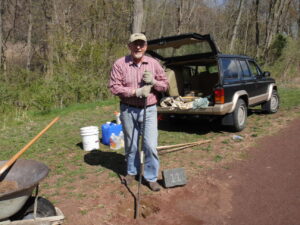
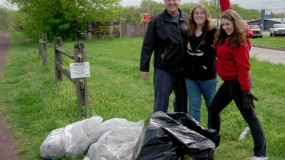
During our annual Canal Clean-up event, which involves groups of volunteers from the local community, schools, and businesses, we spruce up the entire 58.9-mile park. We call it our spring cleaning. Over the years, we are thankful to say, most teams report less trash, fewer signs of vandalism and many appreciative neighbors who applaud their efforts.
In the beginning
Betty Orlemann, founder of the Friends of the Delaware Canal, started this annual tradition. Before Betty came on the scene, other local residents had canal clean-up on their radar. William Francis Taylor, a Lumberville artist and author, formed the Delaware Valley Protective Association, a precursor to the Friends. This organization was responsible for securing an essential National Historic Landmark designation, protecting the canal and towpath for generations to come.
However, the canal remained in poor condition for many years until Betty rolled up her sleeves, enlisted the help of neighbors and began clean-up efforts in earnest. Over time, more volunteers asked how they could help. The Canal Tenders volunteer corps and the Canal Action Teams were established to undertake regular clean ups and larger projects. They have successfully removed tons of debris, restored several historic structures, and removed invasive vegetation. And they became the eyes and ears of the Delaware Canal State Park, a nearly 60-mile greenway that is a challenge for park resources alone to manage.
Supporting the Delaware Canal State Park staff
The Friends are vital partners to the Delaware Canal State Park staff. We raised money to purchase expensive dredging equipment and donated it to the park to remove debris and sediment that impeded the flow of water.
The Friends also took on the task of renovating, restoring, and in some instances replacing the historic camelback bridges along the canal, as well as repairing and repainting fencing, beams, and small buildings. These efforts have significantly enhanced the park’s appearance and the surrounding environment, a source of pride for all involved.
A better place for all
Research has shown that a clean out door space has a profound impact on mental health, decreasing instances of vandalism and fostering a sense of pride and ownership of the public space. Over
the years, we have received numerous calls from neighbors who are willing
to remove trash and tree limbs as they walk along the towpath. This norm of keeping the park clean and welcoming has been embraced by many who value the canal and towpath.
The long-term impact of one woman’s determination to clean up the canal is clearly visible when you walk along the towpath today. Our volunteers carry on Betty’s legacy, and we are so grateful for their support. Their contributions have not gone unnoticed.
HEAVY LIFTING
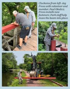 Question: How do you replace a 300-pound wooden beam on a wastegate? Answer: Very carefully
With the help of park staff and a backhoe, several members of the Friends CAT team, along with Executive Director Michael Ginder, did just that. In fact, they did it twice.
The top beams of two waste gates, one located at Maple Avenue in Morrisville and the other in Yardley, were removed and replaced with new 16-foot-long, 6×8-inch white oak timbers that were milled locally by Heacock Lumber in Pipersville. And as with any delicate operation, planning is everything.
Jay Freeo, a member of our CAT team and a structural engineer by training, meticulously prepared each beam by pre-drilling holes to align with those on the existing supports. After the crew removed the old beam, fasteners were inserted to align with the vertical posts. Connection points, which are prone to rot, were addressed before lowering the new beams into place. Precision was key here, and the alignment was perfect.
These beams serve two purposes: one is to act as a fulcrum for the lever used to lower and raise the gate. The other is to create a barrier against the river side of the gate. With the replacement beams now installed and painted, we are confident they will withstand many years of exposure to the elements.
Projects like these exemplify the work accomplished by the Friends throughout the year. One of our primary goals is to preserve and protect the historic structures along the nearly 60-mile length of the canal. Whether it involves replacing, repairing, or repainting, the Friends work to ensure the Delaware Canal and its historic importance are maintained for generations to come.
CONSTRUCTION UPDATE
SEVERAL PROJECTS HAVE BEEN IN PROGRESS this year, and things are moving along nicely. As of the writing of this article, here is the latest update.
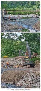
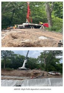 In Upper Black Eddy, the High Falls Creek Aqueduct Replacement project at MP 44.2 is prepped with pedestals installed to receive the culvert the week of July 14. Once the culvert is in place, the restoration of the canal prism and towpath can begin.
In Lumberville, the Lumberville Aqueduct replacement at MP 23.7 is well underway. The abutments, both north and south, are in place. Most recently, the concrete deck to
support the aqueduct was installed, along with steel supports for the towpath.
These projects have had their share of unexpected discoveries. During the excavation for new footings in Lumberville, the construction team unearthed wooden timbers that turned out to be the remains of the original footings, necessitating a redesign to preserve this historic feature.
At High Falls Creek, FEMA and the National Park Service reviewed the project and documented the old culvert before construction began.
Needless to say, the weather has not been kind to these construction teams. Withstanding rain, high temperatures and humidity, they persisted. We truly appreciate their perseverance and hard work in these challenging conditions.
Ancients In Our Midst
The flora and fauna found along the Delaware Canal and towpath are a naturalist’s dream. From the majestic eagles to the elegant herons, the variety of birds found along this nearly 60
mile park is impressive. So are the number of native plant species, from spring ephemerals to historic sycamores.
However, we often overlook some of our oldest residents—the charming and plentiful group of reptiles known as turtles that inhabit the towpath. Pennsylvania is home to 13 species of turtles,
many of which can be found in Delaware Canal State Park.
This time of year, turtle spotting is as easy as finding a half submerged log. Many subspecies of freshwater turtles often congregate in large groups. Other subspecies tend to stick to their own kind. Eastern box turtles, with their distinctive dome shaped shell, are found in wooded and grassy areas, while most
prefer freshwater habitat.
Some of the most common species include painted turtles, red-eared sliders, map turtles, eastern musk turtles and the prehistoric-looking snapping turtle. Other species, such as the northern red-bellied turtle (also known as a cooter) and the spotted turtle, are less frequently seen and are considered threatened or endangered due to their shrinking habitats and declining populations.
EASTERN PAINTED TURTLE
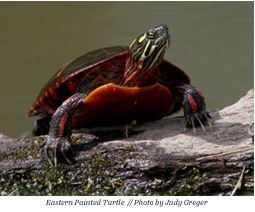 Many of you reading this article may recall a time when, as children, we delighted in bringing home a new pet turtle, complete with a plastic habitat outfitted with a slide and a small fake palm tree. Poor creatures!
Painted turtles are the most widespread native turtles in North America. They can withstand freezing temperatures, a unique ability that allows them to survive in colder climates. However,
the pet trade has negatively impacted their population, leading many states to ban the trapping and sale of these much-loved reptiles. The Pennsylvania Department of Health places restrictions on the sale and distribution of live turtles within the state primarily due to the risk of salmonella contamination.
They are a medium-sized turtle that can grow up to 10 inches in length and can live up to 40 years.
RED-EARED SLIDER
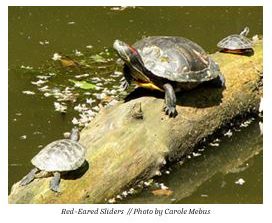 The red-eared slider is a popular pet species that is not native to this area but has become quite common. These turtles are often seen and photographed along the canal. Considered one of the world’s worst invasive species, it is illegal to import them into many countries.
While red-eared sliders may not live as long as painted turtles, their shells can grow up to an impressive 16 inches in length, with females typically larger than males. Their size and aggressive nature pose a threat to native painted turtles and red-bellied turtles by competing for food and habitat.
Like their pond relatives, the painted turtle, red-eared sliders are recognized for the subtle yet striking markings on their shells, as well as their distinctive red ears.
NORTHERN MAP TURTLE
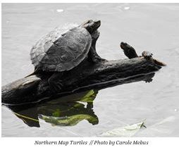 These charming but elusive turtles get their name from the yellow-orange lines that mark the top of their carapace, which resemble the lines on a map. They can grow to a reasonably large
size (up to 11 inches) and prefer moving water to standing water.
Another distinguishing characteristic of the carapace or shell is the flat and flared structure with a somewhat pronounced keel (or ridge) that runs down the middle. In the winter, these normally shy turtles sometimes hibernate with others of their kind, even under a layer of ice, because they have the ability to absorb oxygen from unfrozen water.
EASTERN MUSK TURTLE
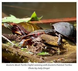 What is not to love about these little turtles? They may come in a small package, but they have superpowers. With their extra
long legs, they can climb steep snags or downed trees and bask in solitude, away from the other turtles crowded on logs. If threatened, they can release a foul-smelling liquid to deter attackers. And don’t be deceived by their playful grin; these little “stinkpots,” as they are affectionately called, can deliver a painful bite.
The Eastern Musk turtle also has the distinction of being the only musk turtle found in Pennsylvania. It spends most of its time underwater and likes to scour the bottom of ponds and lakes in search of food, so it is not as easy to spot as other native Pennsylvania reptiles.
EASTERN RED BELLIED TURTLE OR COOTER
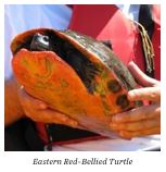 The Eastern Red-bellied Turtle is classified as a threatened species by the Pennsylvania Fish and Boat Commission. To safeguard the Red bellied turtle population, special measures have been implemented to minimize disturbances to their habitat. In the case of the Delaware Canal, work is permitted during the turtles’ active period, which runs from April to October, when they can move away from construction activity.
The turtles hibernate between October 15 and April 15. Therefore, if work on the canal is planned, it must be de-watered by October 15 at the latest, allowing the turtles to find safe places
to hibernate.
The Eastern Red-bellied Turtle is one of Pennsylvania’s largest native aquatic turtles. They can be found in the southeastern and south-central regions of the state, inhabiting slow rivers,
reservoirs, ponds, marshes and ditches. These turtles also spend a significant amount of time sun bathing.
COMMON SNAPPING TURTLE
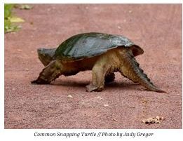 Out of all of the turtles found in the Delaware Canal State Park, the snapping turtle has the most prehistoric appearance. Turtles have existed on Earth for over 250 million years, yet our native snapping turtles seem to have changed little during that time.
These noble creatures have a bad reputation as they can be quite aggressive when threatened; however, if left alone, they coexist well with towpath visitors. They are the largest turtle species in Pennsylvania, weigh up to 45 pounds and measure 18 inches in length. They have a distinctive, long, serrated tail,
As omnivorous scavengers, snapping turtles play an essential role in maintaining healthy freshwater ecosystems. Their large size made them a sought-after food source by indigenous people
and early settlers.
The Delaware Canal State Park provides habitat for so many animals. The next time you’re out walking along the canal, keep a lookout for these fascinating creatures.
OF NOTE: Wild turtles are not pets and should never be removed from their wild habitat. In many cases, it is illegal to do so.
Sources: Pennsylvania Fish and Boat Commission, NatureMappingFoundation.org, Wikipedia, iNaturalist.org
MEMBERSHIP RENEWAL DRIVE 2025
 The FODC 2025 membership renewal drive is off to a great start. In our letter, we highlighted the crucial work we are doing to improve the accessibility of the canal and towpath. We are confident
that the current infrastructure projects along the 58.9-mile park will address several long-standing issues.
The Department of Conservation and Natural Resources (DCNR) has invested a significant amount of funding in our cherished Delaware Canal State Park. We are eager to see progress, especially with major construction projects such as the Lumberville Aqueduct replacement and the High Falls Creek Culvert replacement in Upper Black Eddy.
We extend our sincere gratitude to all our current and past members who responded to our appeal. Your support is the lifeblood of our organization, fueling our planning, education, recreational projects, and our restoration and renovation efforts. With your help, we are set to make a meaningful impact in our community throughout 2025 and beyond. Thank you!
There is still time if you haven’t renewed your membership for 2025.Just scan this QR code to help make an impact.
IN MEMORIAM – ALLEN D. BLACK
On Wednesday, June 18, 2025, we lost another advocate for the Delaware Canal, Allen D. Black. Mr. Black was a long-time member of the Friends of the Delaware and Canal and served on its board for seven years. An active community member, mentor and teacher, Mr. Black will be remembered for his many contributions to Bucks County and beyond
